Developmental goals are in-progress. This is something that is floating around like a common motto in terms of attaining development. But, what strikes your mind first when you hear development. It can be road development, expressways, localities, societies, bridges, institutions and much more. So, albeit the progress graph, it becomes adequately important for the government to keep a notion to build thorough inter-connectivity between cities and states. This in turn affects the economy, growth and development in particular as a whole for the country.
Now to make you aware about some of the developmental projects in the run and fully-established, this article is particularly encircling Kona Expressway, much more known as NH-12. Though, there might be a case when you get yourself confused with Kona Highroad, but they are totally different.
Now, it’s time to delve right into the Kona Expressway, its route, speed limit and much more. Thus, for sure, this article will leave you more enlightened in a sense of relatability with the Kona Expressway project details. So, without further ado! Let’s hop right into it.
Table of contents
All About Kona Expressway
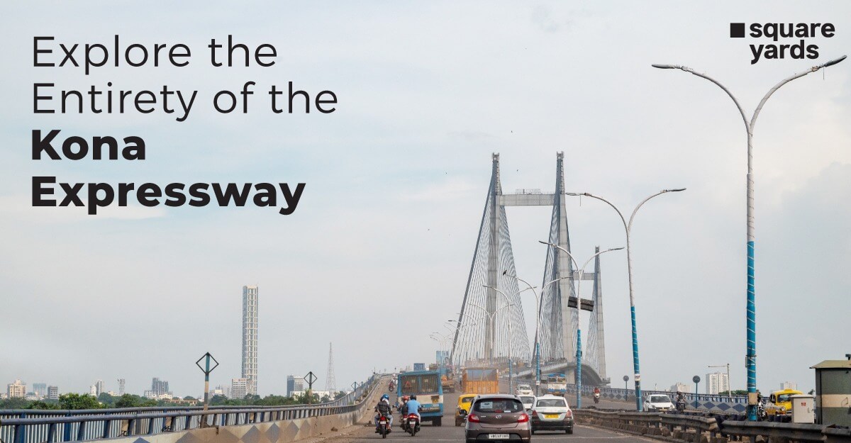
The Kona Expressway is a grade-separated, six-lane, toll-road on the outskirts of Kolkata, West Bengal. It is a 14.17-kilometer (8.80 mi) section of NH 12 and should not be confused with Kona High Road or NH 117. One of the most prominent entrances to Kolkata is through here. The route has been anticipated to have over 70,000 vehicles travelling on it daily till November 2022. Vivekananda Setu, which connects to Kolkata, is connected to National Highway 16 (NH 16) at Kona, Nibra. The highway is a section of NH 12.
Route of Kona Expressway
The HMC or Howrah Municipal Corporation is accountable for the Kona Expressway route, which is located there. In 2001, the route was made public. Among the 3 crucial ways into Kolkata, the Kona Expressway is crucial. The route passes through vital regions, including Carry Road, which links to Andul Road, a crucial Howrah highway that runs parallel to the Kona Expressway. A vital route to Howrah-Amta road and Howrah Maidan, the Kona Expressway, joins with the Drainage Canal road at Belepole. The path also serves as a crucial link to places like Belepole, Santragachi, Gorpha, Jagacha, etc. The Santragachi over-bridge, which passes over Santragachi jheel and railway lines, decreases the route’s 6 lanes (four main lanes and 2 service roads) to two lanes.
The line passes through two significant inter-city rail junctions, Santragachi Junction in Santragachi and Shalimar in the vicinity of the toll centre of Vidyasagar Setu. The road was formerly a link to NH 6 and a section of NH 117. The 3rd biggest station in the Greater Kolkata Area is Santragachi Junction. Along the road lies the Santragachi bus terminus, which acts as the intercity bus terminal for Kolkata and large route buses. A number of buses travel along the Kona Expressway, such as the Barasat-Newtown-Santragachi, Barasat-Ultadanga-Santragachi, KB15 (Santragachi-Anandapur), VS12 (to New Town), 26 (Mini) (Unsani – Esplanade), C11 (Domjur – B.B.D. Bagh or Belgachia), K11 (Domjur – Rabindra Sadan), E7 (Bagnan – Esplanade), EB1A (to Belgharia), E6 (Amta – Esplanade), etc.
What is the speed limit on Kona Expressway for different vehicles ?
The most recent revision to the speed limit for cars travelling on various types of roads was made in April 2018. Currently, cars are only permitted to travel at a top speed of 120 kmph on expressways and 100 kmph on highways. On city streets, the top speed limit is 70 kph. So, this basic outline covers the Kona expressway very well. This shows that the Kona expressway speed limit has a bar set up for 120 km/hr.
Map of Kona Expressway
Below is the image of the Kona Expressway map, which indicates its comprehensive length along with the cities it passes through and nearby famous locations to give you a broader perspective of the same.
Distance of Kona Expressway
The overall distance of Kona Expressway is approximately 15 kms and is one of the most eminent entryways for Kolkata. The route connects a few prominent localities of Kolkata, namely Bandel, Ichapur, Santragachi, Andul, Shibpur and Jagacha. By car, it takes 171 km to travel from the Kona Expressway to Digha. It takes 23 km to travel from Salt Lake City to the Kona Expressway by car.
What About Real Estate Growth in Kona Expressway
The IT/ITeS industry dominates the city’s real estate market. Real estate development is fueled by other industries that create jobs, such as transportation, trade, and manufacturing. Kolkata has the most affordable alternative possibilities because it is primarily end-user oriented. The Kona Expressway, a part of the Golden Quadrilateral project, is projected to experience a lot of growth in the near future. The motorway next to Dankuni will probably experience commercial and industrial growth, which would thereafter spur real estate growth there.
With its advantageous location, the Kona Expressway enables quick access to the CBD, which includes places like Alipore, Park Street, Dalhousie, and Elgin Road. Within 30 minutes, you may be at the Netaji Subhash Chandra Bose International Airport. Santragachi Railway Station, one of the major transportation hubs in Eastern India, is also close by. Several schools are nearby, including DPS, Kalyani Public, and Julien Day Schools. At the intersection of the Kona Expressway, the Avani Group already has a well-established large project on 7.5 acres. With times coming, the Kona expressway will reach the top-level notion of being one of the successful running infrastructures in Kolkata itself.
What is the Current Status of Kona Expressway?
Kona Expressway, after being successfully completed, is very-well operational. Though some new innovative projects have been pipelined, but will be updated once they are completed.
Conclusion
Kona Expressway, an elongated road-network of around 15 kms lying on the outskirts of Kolkata, has made people’s lives better in close proximity. Though it’s merely a small track, it increases feasibility by connecting Kolkata and some of its exclusive localities with a comprehensive expressway. It lies in the category of being one of the full-fledged operation infrastructure projects which are successfully working in Kolkata and takes the credit for making the lives simpler for people there.
FAQ
What is the total length of the Kona expressway?
The total length of the Kona Expressway is approximately 15 kms which is roughly equivalent to 8.8 miles.
Is the Kona Expressway the same as NH 117?
No, it was formerly a section of NH 117, but now it is part of NH 12, which prominently lies on the outskirts of Kolkata.
How many vehicles travel approximately daily on Kona Expressway?
The vehicular limit has reached 70K-80K per day on the Kona Expressway.


